|
01.10.2022 20:39:00
|
Vexcel Releases High-Resolution Aerial Imagery and Property Damage Insights for Hurricane Ian
High-resolution aerial imagery and property damage assessment will help insurers, government agencies, and emergency managers quickly triage damaged areas to enhance their response after the catastrophic hurricane in Florida.
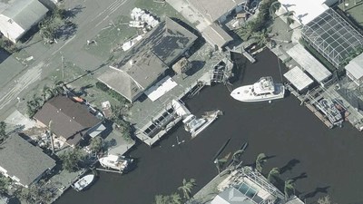
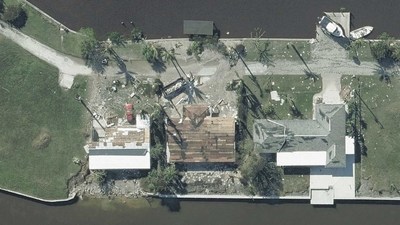
CENTENNIAL, Colo., Oct. 1, 2022 /PRNewswire/ -- Vexcel Data Program, the world's largest aerial imagery program, has collected high-resolution aerial imagery of buildings and properties impacted by Hurricane Ian. The unprecedented level of destruction and scope of this event means thousands of homes, buildings, and other structures are destroyed or have sustained heavy damage.
Vexcel, on the behalf of its partner the Geospatial Insurance Consortium (GIC), activated a full response to Hurricane Ian by deploying multiple fixed-wing aircraft to collect super-detailed imagery at a 7.5-10cm resolution. This imagery is being captured with Vexcel's market-leading UltraCam sensors then put through its world-class processing pipeline and delivered within 24 hours post-collection.
Both orthomosiac and oblique aerial imagery are published, providing multiple views of the damaged areas in Florida.
In addition, Vexcel and GIC will provide property-level damage assessments by applying machine learning to its aerial imagery. The damage assessment includes an overall Post Catastrophic score, approximate FEMA classification, roof damage analysis, and several pre-disaster attributes (roof material, footprint area, roof shape) for every residential building.
Using this aerial imagery and data analytics, users can:
- Better manage and scale responses to heavily impacted customers
- Proactively identify insurance policy holders with damaged property and begin the claims process immediately
- Deploy resources, i.e., field adjusters, utilities, and emergency managers more effectively and safely with detailed information
- Pinpoint key learnings to shore up underwriting and risk policies for future events
Imagery is available in Vexcel's web-based Viewer, partner platforms, and via APIs and Image Services for ArcGIS.
Free Access to Emergency Mangers
Since 2017, Vexcel and GIC have provided their disaster aerial imagery at no-cost to first responders and emergency managers. Emergency teams can request access at: https://gic.org/disaster-response/
MORE INFO
Visit vexceldata.com or gic.org to get more information on imagery available for Hurricane Ian.
About Vexcel Data Program
For 30 years, Vexcel's award-winning technology has led the photogrammetry and remote sensing industry. Using its professional-grade UltraCam sensors and a dedicated fleet of aircraft, Vexcel operates the world's largest aerial imagery and geospatial data program. Vexcel collects imagery in 25+ countries—including rural and urban areas in the contiguous United States. It provides a wide variety of high-resolution products from Oblique to True Ortho, DSM to Multispectral and Property Attributes. Its cloud-based aerial data improves workflows across a variety of industries. Vexcel is the operations partner for the Geospatial Insurance Consortium (GIC). More at vexceldata.com and gic.org.
![]() View original content to download multimedia:https://www.prnewswire.com/news-releases/vexcel-releases-high-resolution-aerial-imagery-and-property-damage-insights-for-hurricane-ian-301638372.html
View original content to download multimedia:https://www.prnewswire.com/news-releases/vexcel-releases-high-resolution-aerial-imagery-and-property-damage-insights-for-hurricane-ian-301638372.html
SOURCE Vexcel Data Program
 Der finanzen.at Ratgeber für Aktien!
Wenn Sie mehr über das Thema Aktien erfahren wollen, finden Sie in unserem Ratgeber viele interessante Artikel dazu!
Jetzt informieren!

